North Lake Leelanau
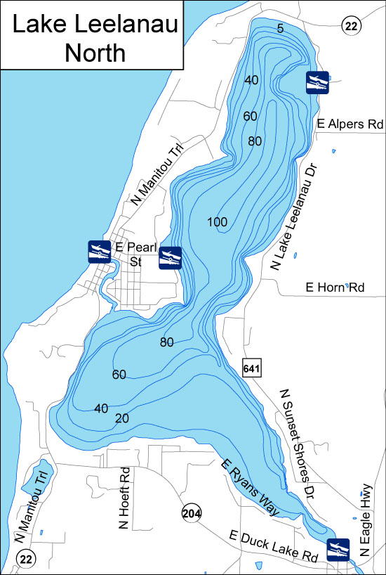
Lake Leelanau lies in the Leelanau Peninsula. The entire lake—which includes two bodies of water, usually referred to as North Lake Leelanau and South Lake Leelanau—covers about 8,608 acres and lies within Leelanau County. The lake is also sometimes known as Carp Lake. Lake Leelanau connects on the northwest to the Leland River, which runs for one mile to Lake Michigan. Between North Lake Leelanau and South Lake Leelanau the water narrows for about a mile near the unincorporated community of Lake Leelanau. A bridge crosses the narrows on M-204. Just south of the bridge is Fountain Point, an historic and scenic landmark as well as a popular summer resort. On the southern end, South Lake Leelanau ends in a marshy area fed by several small creeks, and the waters access the community of Cedar in Solon Township. Lake Leelanau runs 21 miles through the middle of the Leelanau Peninsula; it is about 1.5 miles at its widest. The south lake includes 5,693 acres, the north lake includes 2,914 acres , and the lakes have a total shoreline of about 41.2 miles. The south lake has an average depth of 24 feet , and a maximum depth of 62 feet ; the north lake has an average depth of 40 feet and a maximum depth of 121 feet . Native Americans who first inhabited the area called this land “ke-ski-bi-ag,” which means “narrow body of water,” and called the lake itself “lee-lan-au,” which means “delight of life.”
Sorry we are experiencing system issues. Please try again.